|
TideComp 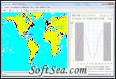
|
Fully featured classic world wide tide predictor. What's the tide doing in Portsmouth, Phuket, the Galapagos or San Francisco?
These are questions long distance cruising and racing yachts frequently need to answer quickly. Even in regions that appear to be free of tides, such as the Mediterranean or parts of the Pacific, the small rise and fall can produce some surprisingly strong currents. Many Polynesian atolls are impossible to enter when the tide is flowing out and, unless you choose your time carefully, a passage through the straits of Gibraltar or Messina can be disturbingly uncomfortable. And if you have the misfortune to run aground on a reef, wouldn't it be useful to know the time of high tide even if it's only a few centimetres?
TideComp provides all the answers, no matter where you are. Its robust mathematical algorithms have been developed over 10 years and used by numerous ocean voyagers and circum-navigators including Whitbread race and Blue water Rally participants.
For local authorities, it is used for planning dredging operations and effluent outflow control, For yacht clubs, it provides advance data for planning events and for Greenpeace, it was the way to obtain tide data for the nuclear test sites of Moruroa and Fangataufa.
TideComp Features:
1. Gives rapid 24 hour graphs showing rates of rise and fall and spot tide heights at any time throughout the day.
2. Prints monthly tables of high and low tide in familiar tide table format.
3. Tables can be saved in HTML format for use in web pages or in other documents.
4. Computes under keel clearance at any state of the tide.
5. Indicates hours of daylight and darkness and Moon's phase.
6. Valid until the year 2050,
7. Data base of over 4000 locations covering all continents (including Antarctica) and hundreds of isolated islands.
8. Search functions allow tide stations to be selected by name or geographical location.
9. Point and click' from a zoomable world coastline chart atlas maps to rapidly locate and identify tide locations.
10. Computes tides at secondary ports. You can build your own personal data base of minor ports, anchorages and creeks.
11. Zoomable world tide selection chart with great circle plotting tool.
TideComp is a long term tide prediction program. It has the ability to produce daily tide graphs and monthly tide tables for any of over 4,500 ports and anchorages throughout the world. Other sections of this help file describe individual functions in more detail but instructions for basic operation can found on this page. Begin by familiarising yourself with its main screen layout of main controls.
Note that TideComp has 3 main screen areas ie the Map and port selection window, the tide graph window and the tide table window. When the program first starts you may not be able to see all three immediately though the visibility and proportion of each window can be resized to suit your own preferences by using the mouse to drag the movable separators that border each window area.
Window areas are activated by clicking the mouse somewhere within them. Notice how this changes the appearance of some tool bar items making some appear 'greyed' and inoperable. Only those that can be used within an activate window area are made functional so for example, you can only use the distance measurement tool in the map window and not on the tide graph or table.
The license of this software is Free Trial Software, the price is $80.00, you can free download and get a free trial.