|
RadioLink 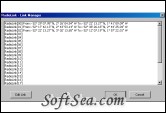
|
Radio Planning Software by Orbit Design using USGS DEM, SDTS DEM, SRTM3, SRTM30, GTOPO30 and Ordnance Survey Landform Profile, Panorama and Panorama Plus map data. Up to 25 radio links can be analised in one project. Calculations include link budgets, terrain profiles and intermodulation products.
Radio propagation design package which will assess the feasibility of a point-to-point radio links prior to any site surveys being carried out. Additional features included to calculate microwave links. This therefore reduces costs on unnecessary trips. The radio path is drawn onto the map using the mouse pointer or by entering the co-ordinates into the Projects manager. Now has LOS and Field Strength Plotting functions. USGS DEM, SDTS DEM, SRTM3, GT0PO30, SRTM30 and Ordnance Survey map data formats is supported. Ordnance Survey map data products that can be used are Landform Profile, Panorama and Panorama Plus.
25 radio links can be evaluated in a single project.
The radio links are added to the project via the Link manager. Upto 25 radio links can be entered for a project, 5 for the Lite version. The link is created by clicking the edit button and entering the co-ordinates. The co-ordinate formats supported are:- Lat/Long (D.M.S), decimal degrees, NGR, UTM, Geographic and QRA.
Link Data
Radio link details are entered using the dialog box shown above. The transmitter and receiver details are entered on the relevant pages. The data for most antennae and feeders are already programmed in. Additional feeders have been included which include the full range of TIMES Microwave Systems LMR, TCOM and FBT coaxial cables. Waveguides are also included for microwave applications. A wide range of antennae have been programmed in which include collinear, Yagi, lens horn and microwave dishes. Climatic conditions can also be entered.
Calculations
The radio link calculations uses various propagation models which include Yokomura/Hata, Hata(150-1500MHz, Cost-231 Hata, Egli and Friss. RadioLink calculates the losses in the coaxial/waveguide feeders, connectors and path losses to produce a link budget which can be viewed and printed out. Line of Sight (LOS) and Field Strength plots can be generated to enable coverage analysis studies for mobile and point-to-point communications. Intermodulation products can be calculated. Transmitter frequencies are extracted from the project details, additional frequencies outside of the projects can be entered such as local transmitters which may affect communications. Terrain profiles can be extracted from the map data for each link and can be saved as bitmap images for use in other documents.
Terrain Profile.
The terrain profile display also shows the antennae mast, radio path and first/second Freznel Zones. The display scale is adjustable.
Link Budget
The Link Budget displays the results and details System gains/losses, Multi path outages/losses Rainfall outages/losses. Budgets can be saved as rtf files.
Intermodulation Input Frequencies
Intermodulation products can be calculated from spot frequencies extracted from the project and additional frequencies added.
Intermodulation Display
The resultant intermodulation products can be displayed as shown.
RadioLink Features:
* Very fast, easy data input.
* Comprehensive Antenna and Feeder databases.
* Instant calculations.
* Path profiles produced using Digital Elevation Models.
* Calculates the path losses.
* LOS and Field Strength plots.
* Extensive Help System.
Reports:
* Path Budget calculations.
* Path profile showing terrain profile and freznel zones.
The license of this software is Free Trial Software, the price is $249.99, you can free download and get a free trial.