|
HF-Prop 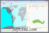
|
HF-Prop is a HF radio propagation predictor. An essential tool for all SSB and short wave radio users. HF-Prop is a essential tool for all SSB and short wave radio users.
Even in these times of Sat-Phones and Cell Phones, High Frequency (HF or short wave) radio remains a most effective and inexpensive method of long distance communication. The equipment is relatively inexpensive and unless you use commercial radio station services to connect into the terrestrial phone system there are no phone bills to pay. When conditions are right, you can communicate with stations anywhere in the world yet, at other times, even the most powerful broadcast stations become submerged in static or fade to nothing.
1. Keep in Touch
The Radio Telephone (Rad-Phone) service is great for keeping up with business or social contacts while you are at sea but can be frustrating if radio conditions are not up to scratch.
2. Get cleaner weather fax charts and satellite images
Good quality weather fax charts are only obtained when signal quality is at its best.
3. For better news and entertainment
International broadcast stations such as the BBC world service, Voice of America etc.
HF-Prop Features:
1. Real time sun position plotter shows regions of daylight, and greyline propagation
2. Preloaded names and positions of Sailmail and Winlink stations and over 300 major cities
3. Great circle route plots, course and distance measurements
4. Split screen map display makes entering positions simpler and faster
5. Map cursor position is shown as both latitude/longitude and Maidenhead QTH locator
When the program is first started, the Map window is hidden and the splitter bar appears at the left of the screen. Place the mouse cursor on the splitter bar, click the left mouse button and drag the bar to the right and the map is revealed.
To identify cities, Winlink and Sailmail stations.
Cities are marked on the map as small dark green triangles, Winlink stations as blue circles and Sailmail stations as green. Move the mouse cursor over any of these spots and its name appears.
Marking your current position
There are two ways of doing this.
1) Place the mouse cursor (notice that the latitude/longitude co-ordinates of the cursor are displayed on the status bar) over your current position on the map and click the left mouse button. Your position to the nearest degree is marked with a yellow spot.
2) Click 'Initial data' on the menu or its corresponding icon (on the left side) of the tool bar. When the Initial data property sheet appears, select the 'Your station position' tab and type in the latitude/longitude co-ordinates of your current position. This method gives better precision than the map window and allows positions in degrees and minutes to be entered.
Marking the position of the station you wish to communicate with
Again there are two methods though the procedure is similar to marking your current position, except that when using the Map window, click the right mouse button and the position is marked with a red spot. At the same time that the distant station is marked, the propagation graph is updated and a great circle course is drawn between the two positions. The status bar shows their co-ordinates, the initial great circle bearing and distance in nautical miles between them.
Setting Initial data
Apart from the positions of the two radio stations concerned, HF-Prop also requires the current date and some solar data. These items are also entered through tabs on the Initial data property sheet. The solar data required includes the Solar flux and Boulder K index. Both of these quantities are given by radio stations such as WWV and WWVH where they are broadcast at 18 and 45 minutes past each hour. Frequencies are 5.0, 10.0 and 15.0 mHz. There are also several internet sites providing the same information (eg. www.dxlc.com/solar)
Solar flux values change slowly, so in the absence of current data a figure for the previous day is sufficient. K index values affect polar propagation paths; the higher the figure, the greater the absorption. Enter zero for the k index if you have no figure available but expect over optimistic propagation predictions on trans polar routes.
Program help
Other pages in this file are your main source of program help. From within HF-Prop you can obtain help by:
1) Selecting 'Help' then 'Help Topics' from the main menu bar.
2) By pressing F1 while the program is running.
Speeding up the map screen display
The map screen display includes a number of advanced features (see below) that require the computer to make large numbers of quite complex calculations. On older machines the effect can be to slow updating of the map screen to an intolerably low speed and the program appears to 'hang' for long periods during which no keyboard can be made. If your computer is affected the problem can be alleviated by switching off the advanced features. Use the Initial Data->Options dialog box to disable daylight shading and display of cities, WinLink and Sailmail stations.
Advanced features
The sun has an enormous effect upon HF propagation and for this reason its current geographical position is plotted on map screen. This is the position where if viewed from the earth, the sun would be immediately overhead (ie in the Zenith) As the earth rotates, the sun appears to move in an westerly direction and its changing position is updated on the map at regular intervals. The default update frequency is 4 minutes though you other intervals can be selected through the Initial Data-> Options dialog box.
Dawn and dusk are times when propagation shifts between night and day time conditions. They are also times of special opportunity for long distance HF communications and referred to as 'Grey Line' propagation. Because of its importance regions of daylight are shown on the world map as a light colour and between the two an intermediate twilight region where the sun is between 6 and 12 degrees below the horizon (ie between Civil and Nautical twilight).
Maidenhead Locators
For radio amateurs, Maidenhead locator is displayed alongside the map screen Status bar alongside the cursor latitude/longitude..
Customising the location files
The files containing positions of major cities, Winlink and Sailmail stations are include within the HF-Prop directory and are named as follows:
cities.txt
winlink_stations.txt
sailmail_stations.txt
These are plain text files and can be edited using a simple text editor such as 'Notepad'. When making changes, deletions or additions make sure that the number of characters per line is kept at 42. Use decimal latitude and longitude positions consistent with existing entries and ensure that the decimal points lie in the same columns.
If you wish, you may delete any of the location files or add an additional file with your own personal listings. This should be called 'user_stations.txt' and should have the same format as the above and be placed in the same directory.
The license of this software is Free Trial Software, the price is $40.00, you can free download and get a free trial.